Marine licensing: Definitions
Definitions of some commonly used terms in marine licensing.
Applies to England and Northern Ireland
Jurisdiction
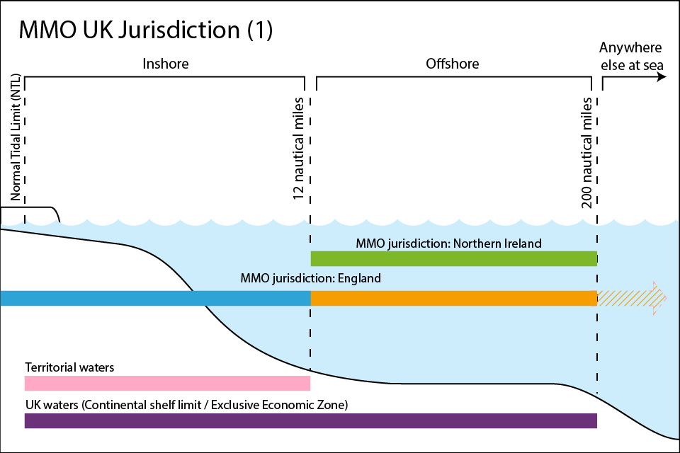
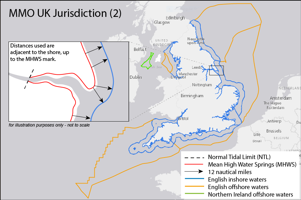
The Marine Management Organisation (MMO) is responsible for marine licensing in English inshore and offshore waters and for Northern Ireland offshore waters.

‘English waters�� is a term used to describe the inshore and offshore area. The inshore area is the area of��sea within 12 nautical miles of the English coastline. This is also called the territorial limit. The offshore area is the area of sea beyond the territorial limit but which is in the designated the English Exclusive Economic Zone (EEZ) and within the UK sector of the��continental shelf. This is up to 200 nautical miles from the coast. The definition of English waters excludes the waters of the devolved administration of Northern Ireland, Scotland and Wales.
‘Northern Ireland offshore waters�� is the area of sea beyond the territorial limit. It is the area designated as the Northern Ireland Exclusive Economic Zone (EEZ) and within the UK sector of the��continental shelf. This is up to 200 nautical miles from the coast. The definition of Northen Ireland offshore waters excludes the waters of the devolved administration of Scotland and Wales, and the administration of England.

Mean High Water Springs
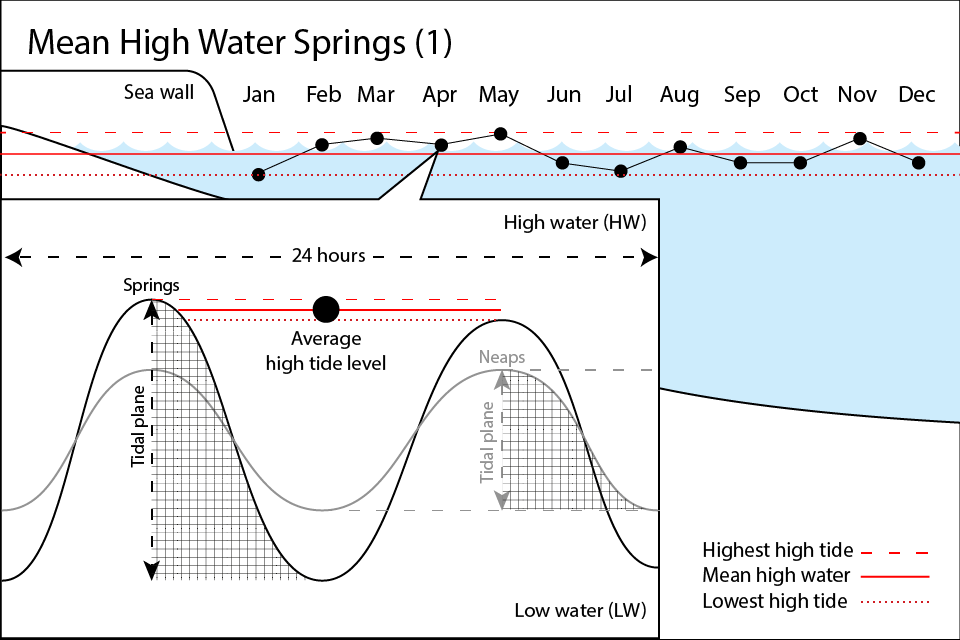
Monthly tides are defined two ways. They are called ‘Springs�� or ‘Spring tides�� when the tidal range is at its highest and ‘Neaps�� or ‘Neap tides�� when the tidal range is at its lowest. In spring tides, the height of Mean High Water Springs (MHWS) is the average of two successive high waters during a period of 24 hours in each month.

It can be difficult to determine the Mean High Water Springs if you do not have access to specialist equipment (for example, a Leiker gauge). We recommend you treat an area as being below MHWS if it is made wet from the normal ebb and flow of the tide or if there is evidence such as marking or growth that would suggest the tide has reached a point in the past.
If you’re still unsure, we recommend that you undertake an independent survey to confirm the position.
Normal Tidal Limit
The Normal Tidal Limit (NTL) describes how much a body of water is affected by the ebb and flow of the tides. This may encompass rivers and their estuaries, including those areas that are controlled by locks.

What do we mean by ‘The Sea��?
‘Sea�� includes any area which is submerged at Mean High Water Springs. It also includes the waters of every estuary, river or channel where the tide flows at Mean High Water Spring tide up to the Normal Tidal Limit.
Waters in areas which are closed (such as docks) but where seawater can flow into or out of are included in the MMOs Jurisdiction. These areas can be closed permanently or occasionally; by a lock or other artificial means, against the regular action of the tide. Seawater can be flowing into or out from the area, either continuously or from time to time.
In or over the sea, on or under the seabed
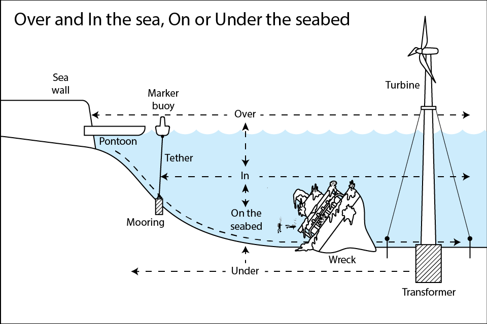
‘In�� the sea is a location within any relevant body of water.
‘Over�� the sea is a location directly above or overhanging the sea. This could be a bridge, open piled structure or cantilever.
‘Seabed�� is the ground under the sea. It includes anything resting on the seabed, such as a shipwreck.

Anywhere else in the world
The MMO is also responsible for marine licensing in other parts of the world for certain activities. Use our to find out if you need a marine licence.
Updates to this page
-
Text amends
-
Update
-
First published.