
Safety flyer to the fishing industry - Coelleira
Published 20 March 2020

漏 Crown copyright 2020
This publication is licensed under the terms of the Open Government Licence v3.0 except where otherwise stated. To view this licence, visit or write to the Information Policy Team, The National Archives, Kew, London TW9 4DU, or email: [email protected].
Where we have identified any third party copyright information you will need to obtain permission from the copyright holders concerned.
This publication is available at /government/publications/safety-lessons-passage-planning-is-key-to-safe-navigation/safety-flyer-to-the-fishing-industry-coelleira
1. Summary
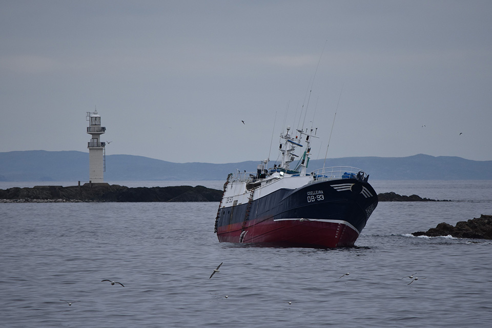
Fishing vessel Coelleira (OB 93), stranding and loss, 4 August 2019
Coelleira aground on Ve Skerries
2. Narrative
Coelleira grounded on Ve Skerries, a group of low-lying reefs 3nm north-west of Papa Stour on the west coast of Shetland, Scotland. The vessel鈥檚 15 crew quickly mustered, donned lifejackets, launched liferafts, and determined that there was no water ingress. The coastguard was informed, and the crew were safely evacuated by rescue helicopter. Attempts by salvors to re-float Coelleira were unsuccessful and it was declared unsalvageable. Coelleira eventually聽slid聽off the rocks聽into聽deeper water聽and sank.
The MAIB investigation identified that:
-
The route from the fishing grounds to聽Scrabster聽was not plotted on paper charts or in the chart plotter. Instead, the skipper altered the vessel鈥檚 heading to follow the coastline, using the radar and chart plotter to keep clear of navigational hazards.
-
Ve聽Skerries聽was possibly not聽displayed on the chart plotter聽due to the quality of the chart聽data, or聽detected by聽radar聽due to the range scale in use.
-
The wheelhouse聽had been聽unattended for some time when the vessel grounded.
-
During the passage,聽Coelleira鈥檚聽skipper maintained the wheelhouse watch alone and it is possible that his level of arousal and awareness were reduced by fatigue due to a disrupted sleep pattern over the previous 2 weeks, and the time of the day.
3. Safety lessons
-
Passage planning is a prerequisite of safe navigation, particularly in unfamiliar waters. Plotting an intended route either on a paper chart or in a chart plotter not only provides an overview of the planned passage, but it also enables all potential hazards to be identified and avoided.
-
Keeping a good lookout does not just require looking out of the window. It also requires tying in what can be seen with what is shown on the chart, and therefore is expected, and adjusting radar displays and chart plotters to ensure that the track ahead is clear.
-
Fishing invariably involves working long and unsociable hours. However, careful management is required to prevent limited opportunities to rest impacting on a vessel鈥檚 safe operation. The ability to work a watch system that ensures wheelhouse watchkeepers get adequate rest and enable the provision of an additional lookout at night, is an essential factor when determining manning levels.
-
Leaving a wheelhouse unattended is never a good move, no matter for how brief a period.
-
Most fishing vessels rely on electronic chart plotters for marking positions of underwater obstructions, fishing gear and successful fishing tows. Due to the advantage that real time positioning provides, chart plotters are also invariably used for navigation instead of paper charts. However, unless the plotters are loaded with up-to-date electronic charts at appropriate scales, they will not be sufficiently accurate for navigation.
Our accident investigation report is available at: www.gov.uk/maib-reports/grounding-and-loss-of-fishing-vessel-coelleira
For all general enquiries:
Marine Accident Investigation Branch
First Floor, Spring Place
105 Commercial Road
Southampton
SO15 1GH
Email [email protected]
Enquiries during office hours +44 (0)23 8039 5500